Hail
Analysis

DW-D
Further Analysis


High possibility of hail occurrence zone


1) 500hPa Temperature: under -12 degrees Celsius
2) 500hPa-400hPa Temperature Difference : over about 10 degrees Celsius
Hail occurrence possible zone
1) 500hPa Temperature: under -9 degrees Celsius
2) 500hPa-400hPa Temperature Difference : over about 6.5 degrees Celsius


Hail size analysis
We used Fawbush-Miller hail size prediction nomogram to compare the real hail size and the predicted hail size using the nomogram.
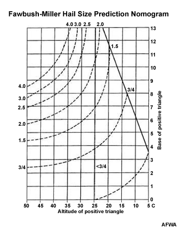

Procedure
-
Identify the CCL and the isobar where the sounding temperature crosses the -5°C isotherm. We will refer to this isobar as -5I
-
From the CCL, proceed up the moist adiabat to where it intersects the -5I. This is point A.
-
From -5°C at the -5I level (Point B), proceed down a dry adiabat to the level of the CCL. This is point C.
-
Take the temperature difference A-B. On the nomogram, this is the base.
-
Take the temperature difference C-B. On the nomogram, this is the altitude.
-
Apply the Fawbush-Miller nomogram 1 to determine the maximum hail size.
Results

We did all the procedure for every cases, and the table on the left is the comparison of the actual size of the hail and the estimated size of the hail. Setting the error range as 0.3mm, 10 cases between 19 cases were included at the rational range. So, we can estimate the accuracy of Fawbush-Miller hail size prediction nomogram as about 52.6%.
The reason why our predicted accuracy is not so high is because we cannot get the Skew-T log P diagram at the exact time when the hail occurred, and we did not selected lots of hail cases. Also, the time when it is occurred and actual size of the hail is not really accurate, too. Therefore, if we supplemented for those limits, we must have had better results.
